
基于Uniapp+vue3实现微信小程序地图固定中心点范围内拖拽选择位置功能及实现步骤
作者:编程猪猪侠
本文分步骤给大家介绍基于Uniapp+vue3实现微信小程序地图固定中心点范围内拖拽选择位置功能,本文结合实例代码给大家介绍的非常详细,对大家的学习或工作具有一定的参考借鉴价值,需要的朋友参考下吧
一、功能概述与实现步骤
1.1 功能需求
- 显示地图并固定中心点标记
- 绘制服务区域多边形边界
- 实时检测拖拽后位置是否在服务区内
- 提供位置确认和超出范围提示功能
1.2 实现步骤分解
第一步:初始化地图基础配置
- 创建Map组件并设置基本属性
- 定义服务区域多边形坐标
- 设置地图初始中心点
第二步:实现地图交互逻辑
- 监听地图拖拽事件
- 获取拖拽后中心点坐标
- 判断坐标是否在服务区内
第三步:实现覆盖层UI
固定中心点标记
位置信息显示面板
操作按钮(确认/返回服务区)
二、分步骤代码实现
2.1 第一步:地图基础配置
<template>
  <view class="map-container">
    <map
      id="map"
      style="width: 100%; height: 80vh"
      :latitude="center.latitude"
      :longitude="center.longitude"
      :polygons="polygons"
      @regionchange="handleMapDrag"
      :show-location="true"
    >
      <!-- 覆盖层将在第三步添加 -->
    </map>
  </view>
</template>

<script setup>
import { ref, onMounted } from "vue";

// 服务区域边界坐标
const serviceAreaPolygon = [
  { latitude: 34.808, longitude: 113.55 },
  { latitude: 34.805, longitude: 113.58 },
  // ...其他坐标点
  { latitude: 34.808, longitude: 113.55 } // 闭合多边形
];

// 中心点位置
const center = ref({
  latitude: 34.747,
  longitude: 113.625
});

// 多边形配置
const polygons = ref([{
  points: serviceAreaPolygon,
  strokeWidth: 2,
  strokeColor: "#1E90FF",
  fillColor: "#1E90FF22"
}]);

// 初始化地图上下文
const mapContext = ref(null);
onMounted(() => {
  mapContext.value = uni.createMapContext("map");
});
</script>
2.2 第二步:地图交互逻辑实现
// 当前坐标点
const currentPos = ref({ ...center.value });
// 是否在服务区内
const isInServiceArea = ref(true);

// 地图拖拽事件处理
const handleMapDrag = (e) => {
  if (e.type === "end") {
    mapContext.value.getCenterLocation({
      success: (res) => {
        currentPos.value = {
          latitude: res.latitude,
          longitude: res.longitude
        };
        // 判断是否在服务区内
        isInServiceArea.value = isPointInPolygon(
          currentPos.value,
          serviceAreaPolygon
        );
      }
    });
  }
};

// 射线法判断点是否在多边形内
function isPointInPolygon(point, polygon) {
  const { latitude, longitude } = point;
  let inside = false;

  for (let i = 0, j = polygon.length - 1; i < polygon.length; j = i++) {
    const xi = polygon[i].longitude, yi = polygon[i].latitude;
    const xj = polygon[j].longitude, yj = polygon[j].latitude;

    const intersect = ((yi > latitude) !== (yj > latitude))
      && (longitude < (xj - xi) * (latitude - yi) / (yj - yi) + xi);

    if (intersect) inside = !inside;
  }

  return inside;
}
2.3 第三步:覆盖层UI实现
<!-- 在map标签内添加 -->
<cover-view class="center-marker"></cover-view>

<cover-view class="info-box" :class="{ 'out-of-range': !isInServiceArea }">
  <cover-view v-if="isInServiceArea">
    当前位置在服务区域内
  </cover-view>
  <cover-view v-else class="error">
    当前选择位置超出服务区域
  </cover-view>

  <cover-view class="coords">
    纬度: {{ currentPos.latitude.toFixed(6) }}
    经度: {{ currentPos.longitude.toFixed(6) }}
  </cover-view>

  <cover-view
    v-if="!isInServiceArea"
    class="recenter-btn"
    @tap="centerToServiceArea"
  >
    查看最近的服务区域
  </cover-view>

  <cover-view
    v-else
    class="confirm-btn"
    @tap="confirmLocation"
  >
    确定上车位置
  </cover-view>
</cover-view>
2.4 第四步:业务功能完善
// 返回服务区中心
const centerToServiceArea = () => {
  const center = getPolygonCenter(serviceAreaPolygon);
  currentPos.value = { ...center };
  isInServiceArea.value = true;

  mapContext.value.moveToLocation({
    latitude: center.latitude,
    longitude: center.longitude
  });
};

// 计算多边形中心点
function getPolygonCenter(polygon) {
  let latSum = 0, lngSum = 0;
  polygon.forEach(point => {
    latSum += point.latitude;
    lngSum += point.longitude;
  });
  return {
    latitude: latSum / polygon.length,
    longitude: lngSum / polygon.length
  };
}

// 确认位置
const confirmLocation = () => {
  uni.showToast({
    title: `位置已确认: ${currentPos.value.latitude.toFixed(6)}, ${currentPos.value.longitude.toFixed(6)}`,
    icon: "none"
  });
  // 实际业务中可以触发回调或跳转
};
三、完整实现代码
<template>
  <view class="map-container">
    <map
      id="map"
      style="width: 100%; height: 80vh"
      :latitude="center.latitude"
      :longitude="center.longitude"
      :polygons="polygons"
      @regionchange="handleMapDrag"
      :show-location="true"
    >
      <cover-view class="center-marker"></cover-view>

      <cover-view class="info-box" :class="{ 'out-of-range': !isInServiceArea }">
        <cover-view v-if="isInServiceArea">当前位置在服务区域内</cover-view>
        <cover-view v-else class="error">当前选择位置超出服务区域</cover-view>

        <cover-view class="coords">
          纬度: {{ currentPos.latitude.toFixed(6) }}
          经度: {{ currentPos.longitude.toFixed(6) }}
        </cover-view>

        <cover-view
          v-if="!isInServiceArea"
          class="recenter-btn"
          @tap="centerToServiceArea"
        >
          查看最近的服务区域
        </cover-view>

        <cover-view
          v-else
          class="confirm-btn"
          @tap="confirmLocation"
        >
          确定上车位置
        </cover-view>
      </cover-view>
    </map>
  </view>
</template>

<script setup>
import { ref, onMounted } from "vue";

// 服务区域边界
const serviceAreaPolygon = [
  { latitude: 34.808, longitude: 113.55 },
  { latitude: 34.805, longitude: 113.58 },
  { latitude: 34.79, longitude: 113.61 },
  { latitude: 34.765, longitude: 113.625 },
  { latitude: 34.735, longitude: 113.62 },
  { latitude: 34.71, longitude: 113.6 },
  { latitude: 34.7, longitude: 113.57 },
  { latitude: 34.715, longitude: 113.54 },
  { latitude: 34.75, longitude: 113.53 },
  { latitude: 34.808, longitude: 113.55 }
];

const center = ref(getPolygonCenter(serviceAreaPolygon));
const currentPos = ref({ ...center.value });
const isInServiceArea = ref(true);
const mapContext = ref(null);

const polygons = ref([{
  points: serviceAreaPolygon,
  strokeWidth: 2,
  strokeColor: "#1E90FF",
  fillColor: "#1E90FF22"
}]);

onMounted(() => {
  mapContext.value = uni.createMapContext("map");
});

const handleMapDrag = (e) => {
  if (e.type === "end") {
    mapContext.value.getCenterLocation({
      success: (res) => {
        currentPos.value = {
          latitude: res.latitude,
          longitude: res.longitude
        };
        isInServiceArea.value = isPointInPolygon(
          currentPos.value,
          serviceAreaPolygon
        );
      }
    });
  }
};

function isPointInPolygon(point, polygon) {
  const { latitude, longitude } = point;
  let inside = false;

  for (let i = 0, j = polygon.length - 1; i < polygon.length; j = i++) {
    const xi = polygon[i].longitude, yi = polygon[i].latitude;
    const xj = polygon[j].longitude, yj = polygon[j].latitude;

    const intersect = ((yi > latitude) !== (yj > latitude))
      && (longitude < (xj - xi) * (latitude - yi) / (yj - yi) + xi);

    if (intersect) inside = !inside;
  }

  return inside;
}

function getPolygonCenter(polygon) {
  let latSum = 0, lngSum = 0;
  polygon.forEach(point => {
    latSum += point.latitude;
    lngSum += point.longitude;
  });
  return {
    latitude: latSum / polygon.length,
    longitude: lngSum / polygon.length
  };
}

const centerToServiceArea = () => {
  const center = getPolygonCenter(serviceAreaPolygon);
  currentPos.value = { ...center };
  isInServiceArea.value = true;

  mapContext.value.moveToLocation({
    latitude: center.latitude,
    longitude: center.longitude
  });
};

const confirmLocation = () => {
  uni.showToast({
    title: `位置已确认: ${currentPos.value.latitude.toFixed(6)}, ${currentPos.value.longitude.toFixed(6)}`,
    icon: "none"
  });
};
</script>

<style scoped>
.map-container {
  width: 100%;
  height: 100vh;
  position: relative;
}

.center-marker {
  position: absolute;
  top: 50%;
  left: 50%;
  transform: translate(-50%, -50%);
  width: 20px;
  height: 20px;
  background-color: #5ca7fc;
  border-radius: 50%;
  border: 2px solid white;
  z-index: 999;
}

.info-box {
  position: absolute;
  top: 20%;
  left: 50%;
  transform: translateX(-50%);
  background: rgba(255, 255, 255, 0.9);
  padding: 12px 16px;
  border-radius: 8px;
  width: 80%;
  box-shadow: 0 2px 8px rgba(0,0,0,0.1);
}

.info-box.out-of-range {
  background: rgba(255, 240, 240, 0.9);
}

.coords {
  font-size: 12px;
  color: #666;
  margin: 8px 0;
}

.error {
  color: #f56c6c;
  font-weight: bold;
}

.recenter-btn, .confirm-btn {
  margin-top: 10px;
  padding: 8px 12px;
  border-radius: 4px;
  text-align: center;
  font-size: 14px;
}

.recenter-btn {
  background: #606266;
  color: white;
}

.confirm-btn {
  background: #409eff;
  color: white;
}
</style>
四、总结
本文分步骤详细讲解了如何使用Uni-app实现地图位置选择功能,从基础配置到完整实现,重点介绍了:
- 地图基础配置方法
- 多边形区域绘制与判断
- 交互逻辑的实现
- 覆盖层UI的开发技巧
- .moveToLocation移动api 只有在真机才能实现,微信开发者工具不支持
- 可直接复制完整代码到单页测试运行,欢迎补充问题
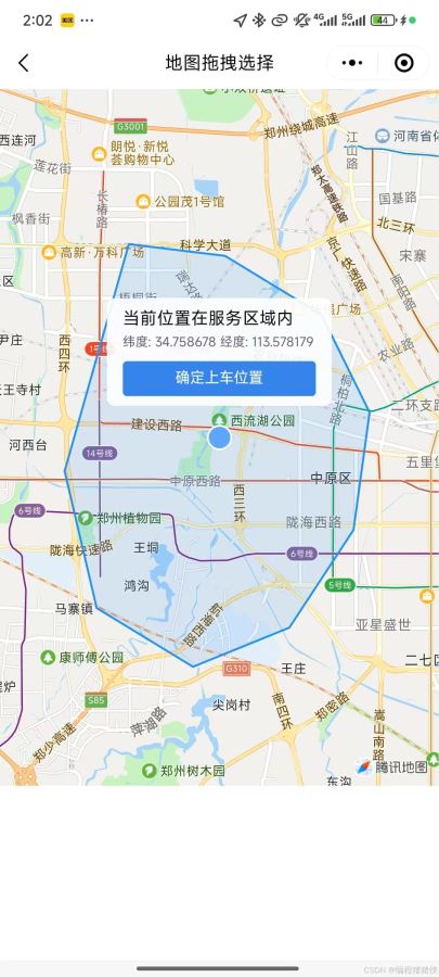
五、实现效果
到此这篇关于基于Uniapp+vue3实现微信小程序地图固定中心点范围内拖拽选择位置功能及实现步骤的文章就介绍到这了,更多相关uniapp vue拖拽选择位置内容请搜索脚本之家以前的文章或继续浏览下面的相关文章希望大家以后多多支持脚本之家!